
Analysis of water use r. rotty elanets
graduate student of the 2nd year of study in the specialty 101 "Ecology"
Nakonechna Yuliia
graduate student of the 2nd year of study in the specialty 101 "Ecology"
PHD in Philology, Ass. professor. Pyanova I.
Odessa State Ecological University, Ukraine
Екологія (Глобальні та регіональні екологічні проблеми)
Analysis of water use r. rotty elanets
The small steppe river Gnily Yelanets (also known as Yelanchyk, Yalanets), beginning in the Bobrynets district of the Kropyvnytskyi region, flows within the Yelanets, Voznesensky, and Novoodesky districts of the Mykolayiv region, serving as a left tributary of the Southern Bug River. The length of the watercourse is 103 km, the catchment area is 1235 km2 [1]. Evolutionarily, the Gnily Yelanets River functioned as a typical drainage watercourse of the Prydniprovska Vysochyna, which, along with the Mertvovid and Ingul rivers, forms a developed drainage network from its southern slope.
With a deficit of precipitation and surface runoff in the summer-autumn period, the flow of the watercourse due to drying of most parts of the river stops, which turns the river Gnily Yelanets into a cascade of isolated reservoirs and ponds [2]. But, serving as practically the only watercourse of Yelanets and Novoodesky districts, the territory of which is generally limited by water reserves, this river retains the value of a potential water reservoir.
The source materials are the results of own field research of Gnily Yelanets on a set of indicators in October 2020 - May 2021. Literature data were also used [3 - 5].
In modern conditions, the Gnily Yelanets River is an artificially transformed reservoir that preserves the hydrologically natural mode of functioning only in the upper reaches. The blurring of the sedimentary stratum forms a sharp expansion of the river valley (from 0.4 to 2.3 km) at a thalweg cut-in depth of 50 - 57 m, which created a deep (up to 9 m) reservoir-reservoir. Kamyanske (Yelanetske) reservoir was established in 1972 - 1973 for the purpose of local water accumulation and is now located below the village. Velidarivka to the village of Kamyanka (3.6 km) with a water volume of up to 5.6 million m3. It is the basis of a small Yelanets irrigation system with an area of 0.6 thousand hectares. Irrigation of lands took place from 1973 to 1992.
In the middle section of the river (below the village of Bukhovetske) the river valley widens to 4.5 km and takes the right tributary of the Solon River. The combination of these two watercourses forms the lower reaches of the Gnily Yelanets River. The river below the village. Shcherbany in 1979 was blocked by a dam 11 m high, resulting in the Shcherbaniv Reservoir with an area of 385 hectares. Due to this reservoir around the village. In Shcherbani and along the highway Nova Odesa - Yelanets, several irrigation zones with a total area of 1.2 thousand hectares were created, which do not function today [6, 7].
Below the Shcherbanivsky Reservoir, the Gnily Yelanets River passes into the pre-estuary zone, which is characterized by an unstable flooding regime and, as a rule, retains only underground runoff in summer and autumn. The mouth of the river is located on the northern outskirts of the village. New Odessa (Fig. 1).
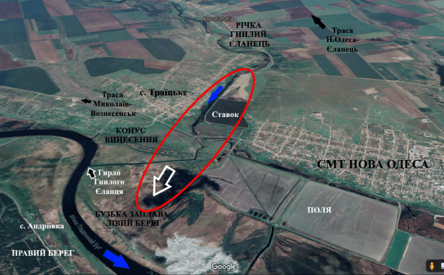
Fig. 1. The mouth of the Gnily Yelanets River [8]
From the economic point of view, the assessment of the use of the waters of the Gnily Yelanets River, given their limited nature, is difficult to determine due to the lack of functioning of irrigation systems and drinking water supply. Determining the level of water efficiency can be done by the value of the water utilization factor:
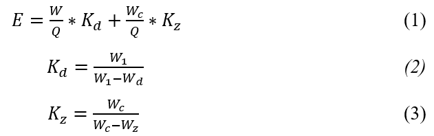
where W is the volume of gross water consumption, Wс - total volume of discharged wastewater, Q - the volume of output per year, Kd and Kz are the coefficients of drinking water and polluted wastewater use waters, W1 is the volume of fresh water actually used, Wd and Wz are the volumes of drinking and discharging actually used contaminated wastewater [9].
The obtained data for 2020 indicate the minimum (about UAH 1.3 million) volumes of efficient water use, which is due to the significant costs of maintaining the functioning of reservoirs, regulation of their water regime and initially significant volumes of accumulated water use. In the case of revival of local irrigation systems involved in Shcherbanivske and Kamyanske reservoirs, with a total area of irrigated land within 1.8 thousand hectares, the efficiency of water use and the corresponding cost of renting water resources is estimated at 173 million hryvnias (as of 2020) .
Thus, the obtained characteristics of the Gnily Yelanets River indicate that it is a hydrologically unstable watercourse of the Steppe zone, which during the last 45 years has undergone significant anthropogenic transformation due to the creation of reservoirs and artificial direction of the river.
Literature:
- Surface water resources of the USSR. Description of rivers and lakes and calculations of the main characteristics of their regime. T.6. Ukraine and Moldova. Issue.1. Western Ukraine and Moldova (without the Dniester river basin). Leningrad, 1978. S. 179 - 182.
- Khilchevsky VK, Chunaryov OV, Romas MI Water resources and river water quality of the Southern Bug basin. Kyiv, 2009. 183 p.
- Opalov OA Ecological and economic assessment of water use in the bass its rivers Southern Bug. Ecological and economic assessment of water use in basin water management complexes of Ukraine. Electronic resource: URL: http://eco.com.ua/content/ ekologo-ekonomichna-ocinka-vodokoristuvannya-v-baseyni-riki-pivdenniy-bug (access date: 14.06.2021).
- Kozlova NV Methodological aspects of economic evaluation of water as a natural resource. Electronic resource: URL: https://cyberleninka.ru/article/n/metodologicheskie -aspekty ekonomicheskoyotsenki vody kak prirodnogo resursa (access date: 14.06.2021).
- Jacyk AV, Gopchak IV Ecological assessment of surface water quality by relevant categories. Methodical instructions. Rivne, 2012. 26 p.
- Information on an ecological and reclamation condition on the irrigated and adjoining lands and level of ground waters in rural settlements for the post-irrigation period of 2019 across the Nikolaev area. Regional office of water resources in the Nikolaev area. Electronic resource: URL: https://mk-vodres.davr.gov.ua/ ameliorative_condition (access date: 14.06.2021).
- Regional statistics. Statistical bulletin. Socio-economic situation of the region (in the Nikolaev area). Electronic resource: URL: https://ukrstat.org/uk/druk/publicat/kat_u/2019/soc_ek_reg/publ_arch_reg2020_u.htm (access date: 15.06.2021).
- Google Earth on the Internet. Electronic resource: URL: https://www.google.com/intl/en/earth/ (accessed: 15.06.2021).
- Marushchak IA Methods and models of ecological and economic assessment of water resources of the Southern Bug. Intelligence XXI. 2017. № 4. S. 120 - 127.